Inks Lake State Park

Kelly, Bettina, Suzanne, Maria on the trail at Inks Lake. (Judy is taking the pic)

Destination: Inks Lake State Park

Date: January 25 & 26, 2020

HikeCampHikers: Judy, Maria, Bettina, Kelly and Suzanne

Travel Time from Austin: 1.5 hours

Campsite: We decided to forego the primitive camp site this trip so that we could have a fire. We reserved site #349 and that was a good thing because all campsites were completely booked, even the primitive sites. Our site bordered the lake and was spacious enough to easily accommodate 5 tents (limit of 8 people per site). We looked at other sites and decided that reserving site #349 and #341 would make a great group site. Also site #346 was another good option, lots of room for tents, private, and on the lake.

Saturday Hike: We went for a long hike that started close to our campsite and crossed the main road and looped around the primitive camp sites.

Sunday Hike: We broke down camp and had breakfast and left for Balcones Canyonlands National Wildlife Refuge and hiked on the trails there before heading back to Austin. It was our first time there, the trails were nice and it was fun to do something different.

Camp food: Kale salad, green beans and tomato soup. Lots of yummy white cheddar.

On our hike at Balcones Canyonlands

Lost Maples State Natural Area

Maria, Kelly and Suzanne on Saturday's hike on the West Trail.
Maria, Kelly and Suzanne on Saturday’s hike on the West Trail.

Destination: Lost Maples State Natural Area

Date: May 14th and 15th, 2016 (Finally, we’re back after a long time without a weekend hiking trip)

Travel Time from Austin: 2.45 hours

Participants: Kelly, Judy, Maria, Suzanne (Bettina was in Hawaii)

Saturday Hike:  We backpacked from the parking area at the West trailhead to G primitive camping area. About a 3 mile hike with steep climbs to the camping area.

Sunday Hike: We packed up Sunday morning, hiked from our campsite with plans to drop off our backpacks and hike the East Trail. Rain clouds gathered while we tossed our gear in the trunk and we decided to head back to Austin instead.

Bird of the Trip: Black Capped Vireo also the Common Raven

Campsite: G primitive camping area

Camp Food: Incredible Curry by Kelly. A tip on beer and backpacking: wrap each chilled beer in newspaper and then pack them in an insulated lunch bag. They stayed cold for over six hours!

IMG_8085

Maria, Kelly and Suzanne spotting a Black Capped Vireo while hiking on the West Trail Saturday afternoon.

I’ve highlighted our hike on the map below. Here’s a link to a PDF of the map from the park’s web site.

pwd_mp_p4507_074b

Queens River Loop – Sawtooth Wilderness, Idaho

K91

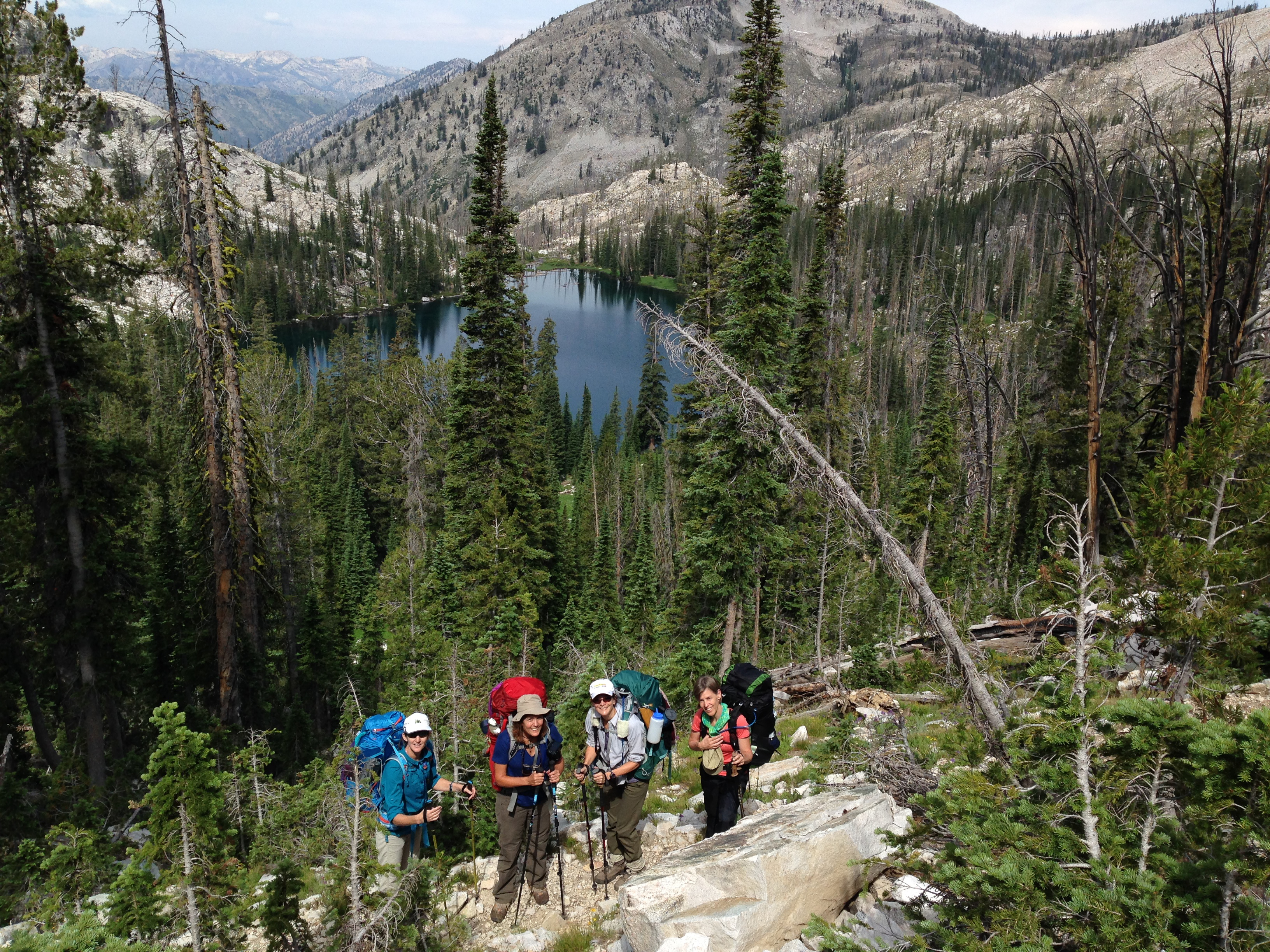
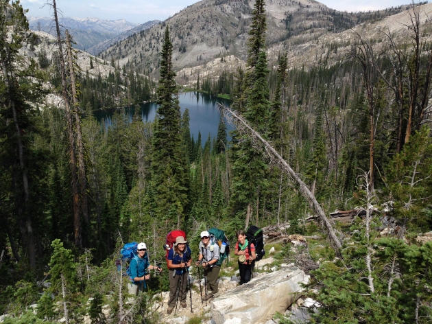
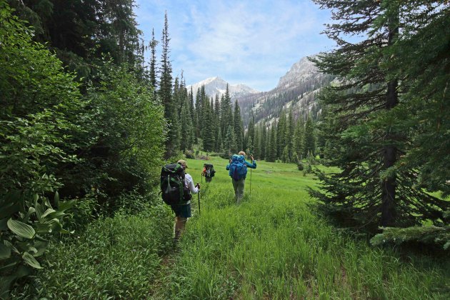
On day 3 hiking from Pats Lake to Everly Lake with Arrowhead Lake in the background. Photo by Kelly Fitzgibbon. 

Destination: Sawtooth Wilderness, Queens River Loop with side trips to Everly Lake and Rockslide Lake

Date: July 4-11, 2015

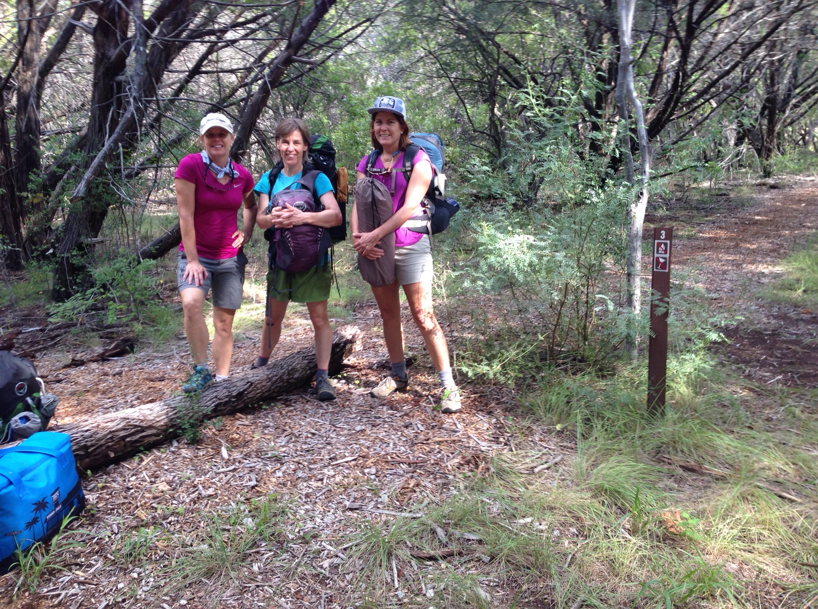
HikeCampHikers: Bettina, Judy, Kelly, Maria, Suzanne
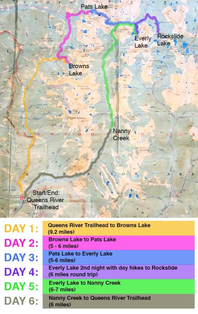
Trip Itinerary:
Pre-hike: Fly to Boise, spent the first night at The Beaver Lodge in Atlanta, Idaho

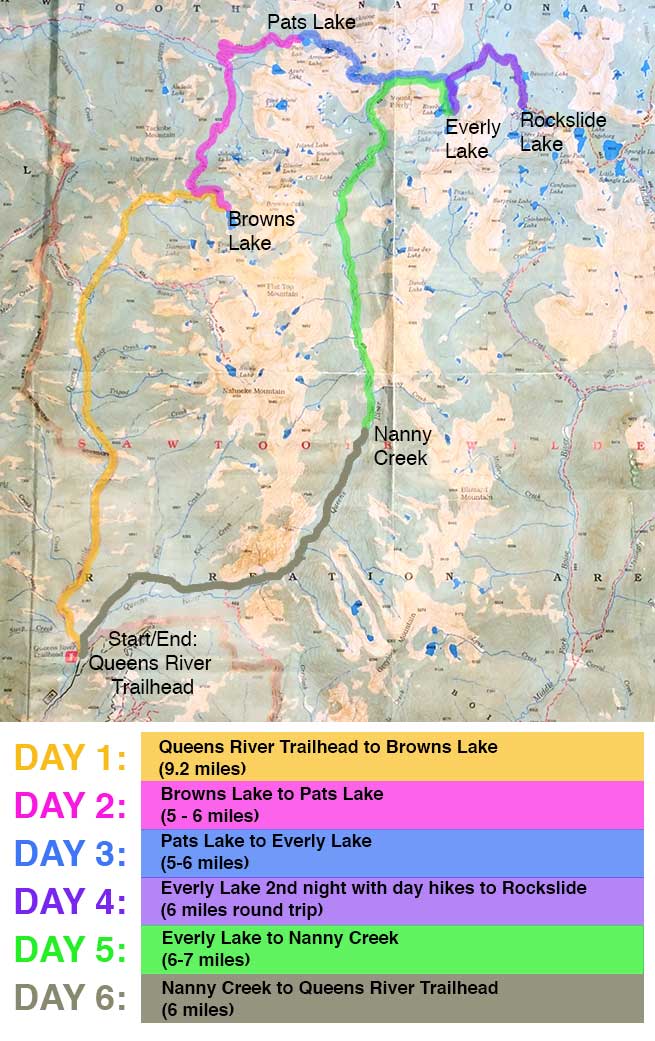
Day 1: Queens River Tailhead to Browns Lake
Day 2: Browns Lake to Pats Lake
Day 3: Pats Lake to Everly Lake
Day 4: Everly Lake for 2nd night with a day hike to Rockslide Lake
Day 5: Everly Lake to Nanny Creek
Day 6: Nanny Creek back to Queens River Trailhead

Post-hike: Eat burgers, visit the hot springs and spend the night at The Beaver Lodge. In the morning drive back to Boise and catch the flight back to Austin.

Special thanks to Michael Lanza and The Big Outside for his expert advice on this trip itinerary!

Hiking through a lush, grassy meadow on our way to Nanny Creek on day 5.

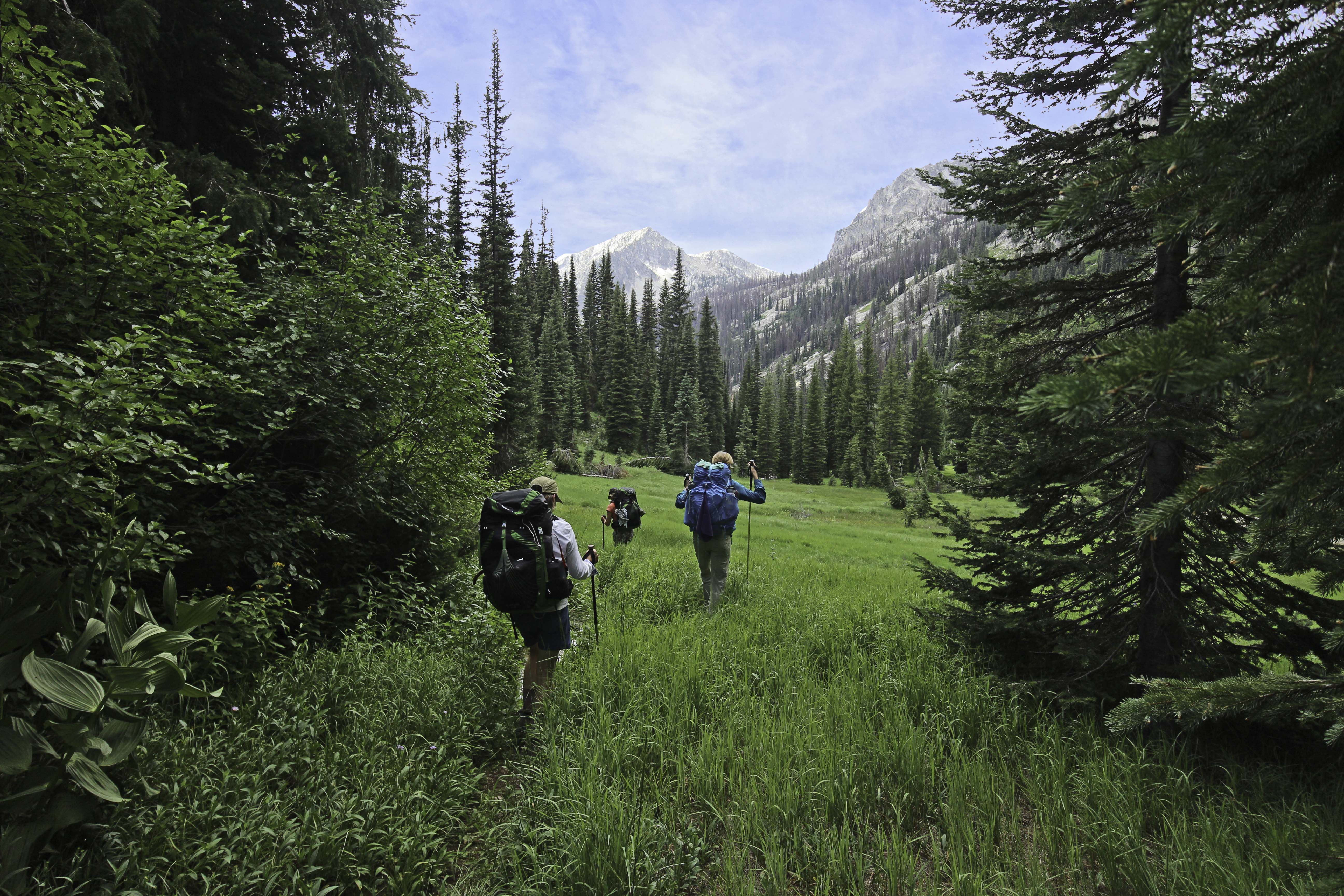
Hiking through a lush, grassy meadow on our way to Nanny Creek on day 5. Photo by Judy Paul.
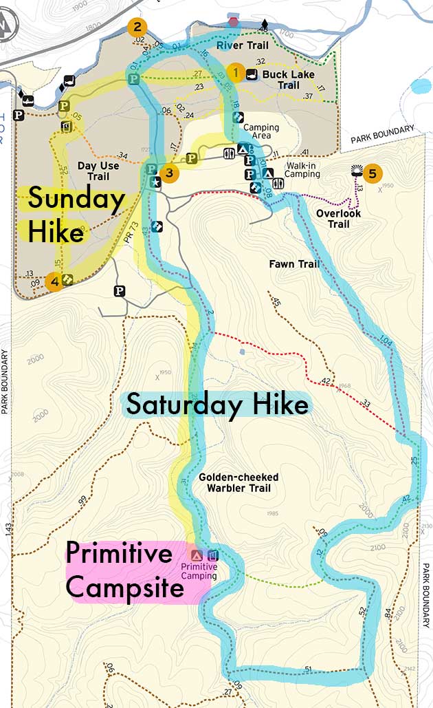
Trip Map:

mapwflat


IMG_5448

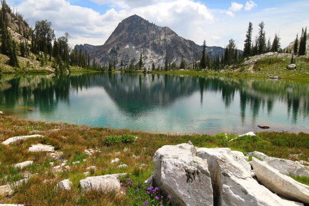
Beautiful alpine lake between Pats Lake and Everly Lake. Photo by Judy Paul.

K9

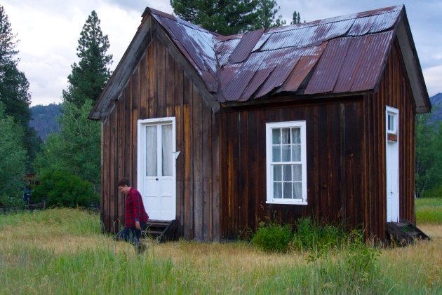
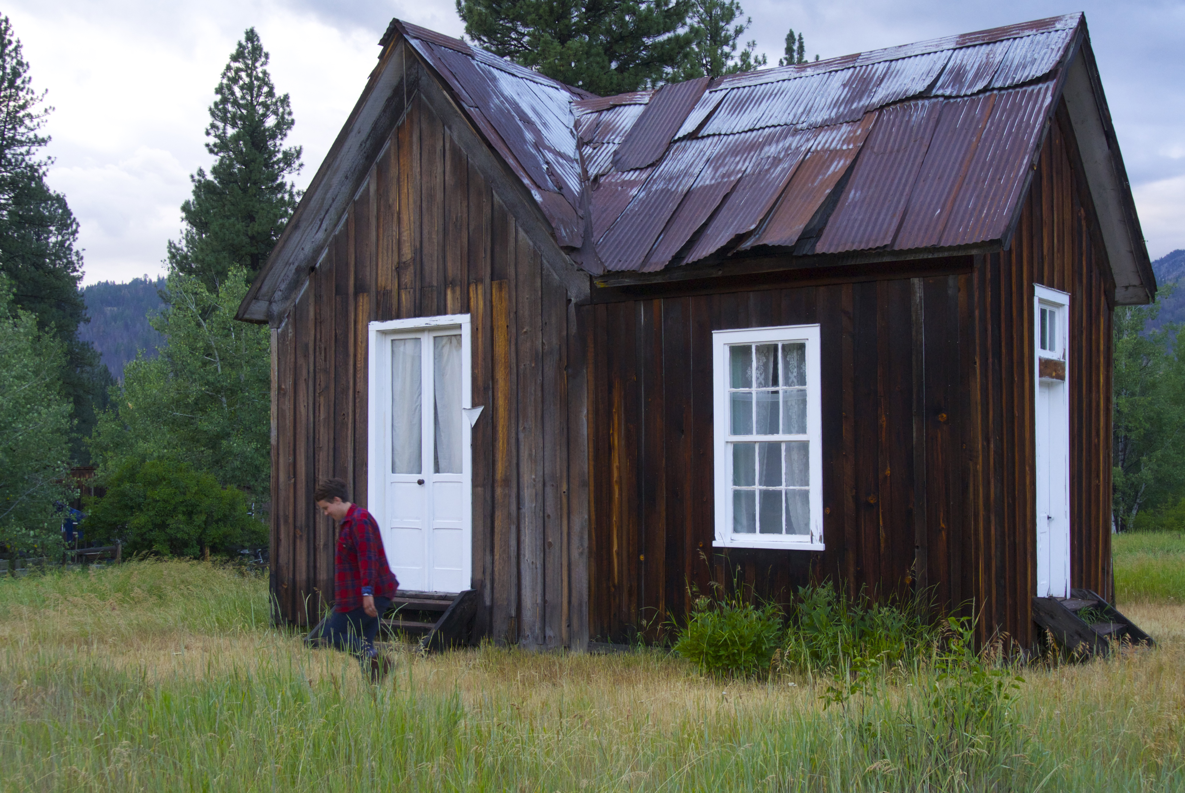
We were lucky enough to tour of some of the re-built, historic mining shacks lead by the artist/owner of the Atlanta School. Photo by Kelly Fitzgibbon.

Trip Story:

Atlanta Idaho is so far off the beaten path that we almost needed the compass to us get there from the Boise airport. Exploring this charming, historic mining town was an unexpected bonus to our trip. We met the quintessential mom and pop owners of the Beaver Lodge and a friendly gang of artist on main street who spend their time making art and restoring mining shacks at the Atlanta School.

Atlanta is just a short drive to the Queens River trailhead so after breakfast at the lodge we piled in the rent car and headed out. Once at the trailhead we completed the self-serve wilderness permit and started the 10 mile trek to Browns Lake. On our way we encountered a bear, lots of burned trees from the fire in 2013, beautiful wildflowers and the only people we would see for the entire rest of the trip. Four people total in six days.

Day two brought us into higher attitudes with wide vistas of the stunning, jagged Sawtooths. As we made our way to Pats Lake we lost the trail when crossing a vast, lush meadow. We backtracked a bit, got out the compass, consulted the map, read the guidebook over and over and finally just went in the general direction we knew we needed to go and relocated the trail. This was the first of many times the trail seemingly disappeared. Eventually we weren’t that shocked when we got off track and mostly just kept going until the trail re-appeared. Navigational know-how, map, compass and guidebook were very helpful on this trip. By this point we were feeling pretty good about our outdoor skills such as using the PCT method of hanging our bear bags and when a huge dead tree fell one windless morning we were thankful we had decided that spot was too risky for our tents the night before.

We arrived at Everly Lake on day 3 and stayed 2 nights using it as base camp for day hikes. Kelly and Bettina did the 6 mile round trip to Rockslide and the rest of us took it easy with a walk to Plummer Lake where we were rewarded with the sight of a regal Golden Eagle overhead. Everly is a beautiful, remote spot with views of the rugged sawtooth mountains that surround the teal waters of this alpine lake. Mosquitos were thick here so our head nets came in handy.

From Everly Lake we hiked to the crossing of Nanny Creek and the Queens River, about a 6 mile trek. Based on the map and the guidebook description, we thought we were at the right spot where Nanny Creek crosses the Queens River but we didn’t see the creek. Eventually Bettina spotted a moss-covered sign high on a tree that said Nanny Creek so we knew we were in the right place. That evening we did some exploring and found an impressive waterfall about 1/2 mile east off the trail. We survived a dramatic thunder and lighting storm that night and the next morning we headed back to the Queens River tailhead. On the 6 mile hike back we encountered a few knee-deep creek crossings, a hail storm and several occasions of losing the trail. Thankfully we spotted a tiny orange flag on tree branch on one of the crossings that marked our way. Once back to our cabin we flipped coins for who got to shower first, ate burgers at the Beaver Lodge and soaked in the hot springs just outside of town. We can’t wait to explore more of the Sawtooths!

k4

Atlanta Natural Hot Springs were a treat after 6 days on the trail!

Maps and Guides: Earthwalk Press Sawtooth Wilderness Hiking Map and Guide, Backpacking Idaho by Douglas Lorain

Food Notes: Mary Janes Farm Outpost backpacking food was our favorite brand of prepackaged meals. REI sells it online and in some stores. Mary Janes Chilimac was the best of all we tried. Curry in a Hurry was Maria’s least favorite. Moon Cheese was also a big hit as was Backpacker’s Pantry Creme Brulee.

Gear Highlights: After trying three different backpacks, Suzanne loves her Osprey Aura AG 65. She says “Both the hipbelt and the harness are adjustable so I was able to dial in the fit.  It also has a lot of great features like external pockets and the handy “stow-on-the-go” loops for trekking poles. It’s a keeper, for sure.” Maria and Suzanne both have a Sawyer Squeeze Filter System and we are all very happy with its performance and ease of use. 

Birds of the Trip: Golden Eagle, Bald Eagle, American Three-toed Woodpecker and the Black-backed Woodpecker.

Photos:
Check out more trip photos by Judy, Kelly and Maria.

Inks Lake State Park (primitive camp site this time)

photo

Kelly, Bettina and Judy in front of primitive camping site #3. Photo by Maria

Destination: Inks Lake State Park

Date: September 27 & 28, 2014

HikeCampHikers: Judy, Maria, Bettina, Kelly (Suzanne broke her toe and couldn’t make it )

Travel Time from Austin: 1.5 hours

Campsite: Backpack Primitive campsite #3. The primitive campsite ended up working great for us. You can’t park your car at the entrance to the primitive camping area but there is a unloading spot that we parked and hiked in, set up our campsite then hiked back to the car and parked it inside the park area and started our Saturday hike from the trailhead at the parking lot that is near the park headquarters.

The website for Inks Lake doesn’t have the Hiking Trail Guide posted so I borrowed this from https://www.sctxca.org. You can get a copy of this map at Inks Lake park headquarters.

Saturday Hike: The primitive campsite we stayed in is located along the yellow “Pecan Flats Trail Camp” area. We hiked the yellow trail to red to the blue loop and back to site 3 in the primitive camp area.

Sunday Hike: We packed up and hiked yellow to green and then on through the park to the trail in the Devil’s Waterhole area.

Camp food: We brought an ice chest so we could expand our dinner choices (and cold beer and wine!). We had a chicken salad contest between Russell’s bakery and Upper Crust Bakery. It was close but Upper Crust won.

Rae Lakes Loop – Kings Canyon National Park

group1.1000

Judy, Bettina, Suzanne, Maria and Kelly on day 1 between Mist Falls and Paradise Valley.

Destination: Kings Canyon National Park, Rae Lakes Loop

Date: August 24 – 31, 2014

HikeCampHikers: Maria, Judy, Kelly, Suzanne, Bettina

Travel Time from Austin:
Flight to San Jose on Southwest Airlines: 3.5 hours
Drive from San Jose to Kings Canyon National Park: 3.5 hours

Trip Planing: We met 3 times for planning the trip. In March we applied for the wilderness permit. Once we had the permit we met to plan the itinerary. And we met another time to divide up the shared equipment and weigh our packs.

Trip Training: We each have our own workout routines. Bettina and Suzanne are rowers, rowing and training for rowing keeps them in great shape. Myself, Maria and Kelly each run, ride bikes and hike to keep in shape. But to prepare for this trip we made time to get together and hike with weighted packs 4 or 5 times before we went on the hike. We can’t get the altitude training in Austin that we encountered in Kings Canyon but the heat of the summer in Austin made it very challenging.

Trip Itinerary:
Pre-hike: Fly to San Jose and spend the night at Cedar Grove Lodge

Day 1: Roads End to between Middle and Upper Paradise Valley.
Day 2: Paradise Valley to Woods Creek Crossing
Day 3: Woods Creek Crossing to Rae Lakes
Day 4: Rae Lakes to Vidette Meadow
Day 5: Vidette Meadow to between Charlotte Creek and Sphinx Junction
Day 6: Between Charlotte Creek and Sphinx Junction to Roads End

Post-hike: Eat burgers, drink a cold one and spend the night at Cedar Grove Lodge. In the morning drive back to San Jose catch the flight back to Austin.

Park and Trip Map:
This trail allows for options on where to camp and we had a few different ways we thought we might do the trip. The itinerary above was the one that we went with for a variety of reasons and it worked out perfectly for us. Each day the scenery was beautiful and offered something different from the day before. Each camping spot was spectacular in it’s own way. We were challenged as far as hiking goes each day but none of us felt like we were pushed beyond what we were prepared to do.
Here is a link to a map of Sequoia and Kings Canyon. Below is a detail of the map with our 5 night/6 day hike highlighted:

raelakesloop3

Food Notes:  Food storage is required since this is Bear Habitat. Some of us used a Bear Vault and Suzanne rented a lightweight canister from Wild-ideas.net. Some of our favorite foods of the trip included Mary Jane’s Farm selection of backpacking food, Wheatsville Food Co-Op‘s bulk Pea Soup with chorizo sausage, Whole Food’s Turkey Jerky, Epic Bars, Wild Garden Hummus to go, Jif peanut butter to go and Arnold Sandwich Thins, beef sticks, dried apples, banana chips, biscotti cookies all from Trader Jo’s.

Birds of the Trip: American Dipper, White-headed Woodpecker, Chickadee, Western Tanager and Rufous Hummingbird.

Photos:

See all the photos from the Rae Lakes Loop Trip here

South Llano River State Park


river

We saw a snake just below us in the river so we moved (quickly) to where the other swimmers were before getting in.

Destination: South Llano River State Park

Date: May 31 & June 1, 2014

HikeCampHikers: Suzanne, Bettina, Kelly, Judy

Travel Time from Austin: 3 hours

Park Notes: Wow! Birds! We saw all types never seen before (by me), even Suzanne (our bird expert) was excited and impressed with the number and varieties of birds. This park will be a favorite destination especially in summer since it has the river which we hopped in after our hikes on Saturday evening and again on Sunday morning. Maybe we’ll even bring our bathing suits next time. And the primitive camping spot, with a mile and a half hike in, was remote and we had it all to ourselves.

feature1

We forgot our swimsuits but were not deterred.

Campsite: Primitive Campsite

Bird(s) of the Trip: Painted Bunting – incredible color! Other sightings included the Summer TanagerVermilion FlycatcherHouse Finch and Indigo Bunting

Equipment Highlights: Since we swam in our undies Bettina and Kelly had a contest to see who’s pair of fancy new hiking panties dry fastest. Kelly has a pair of Smartwool brand Women’s PhD Seamless Boy Short and Bettina’s are REI brand Seamless Briefs.  Both pairs dried by the time we got back to camp, everybody was a winner. Kelly also has a new sleeping bag, the Sierra Designs brand Backcountry bed. She was very happy about it. It looks so comfy I am thinking of getting one too.

Camp Food: Thanks to Suzanne we all tried the Epic Bison Bar. It was actually very tasty. We will be packing some of these protein-packed bars on our Rae Lakes Loop epic Backpacking Trip this July. Don’t get the wrong idea, we had our usual spread of great food in addition to the bars. Bettina cooked penne pasta at home and packed it along with pesto, just picked tomatoes, avocados and parmigiano-reggiano, delicious! We (me) hauled an ice chest the 1.5 miles to the campsite and we had cold wine and beer with dinner. Worth it! Oh and I can’t forget to mention a stop at a Valero gas station in Johnson City  the “Dixie Quick Stop” with the most amazing selection of mexican pastries! YES! Get a Churro and bring me one please.

Saturday Hike: We parked in designated spot for primitive camp sites behind the park headquarters. We hiked in and set up our tents and started hiking from our camp on the Golden-cheeked Warbler Trail to the Fawn Trail through the camping area to the Tube Takeout spot at the river. We took a swim and hiked back to our campsite. 6 miles

Sunday Hike: We packed up and hiked back to the car, unloaded gear and hiked to the day use trail past the log barn (#4 on the map) and to the river for a swim, then back to the car. 3 miles

trail

Hiking through a beautiful pecan grove on Sunday’s hike.

Here is a link to the park’s trail map. Below is a detail of the map with our hikes highlighted:


hikemap


Photos:

See all the photos from the South Llano River State Park here.

Government Canyon State Natural Area

Suzanne, Maria, Bettina and Kelly hiking along the Far Reaches Trail.

Suzanne, Maria, Bettina and Kelly hiking along the Far Reaches Trail.

Destination: Government Canyon State Natural Area

Date: April 12 & 13, 2014

HikeCampHikers: Suzanne, Maria, Bettina, Kelly, Judy

Travel Time from Austin: 2 hours. We took IH35 on the way to the park and ran into traffic. The Google maps lead us to a road that is gated off with no access to the park. We called and got directions from the helpful rangers at the park. Evidently we aren’t the first ones who have been lead astray by using google maps to get there. We took 281 to get back and preferred that route.

Park Notes: We were happy to find the Government Canyon’s staff informative and super friendly when we asked for insights on hiking in the park. Government Canyon has miles of trails which are well maintained and easy to follow. We weren’t quite so happy about the sharp, rocky tent pads at the campsites.

Campsite: G15 – Group Tent Campsite – walk in 60 yards. It  has a 16 person capacity but we were pretty tight on space with our 5 tents. The trailhead to the Recharge Trail is right outside this campsite making it convenient to get started on our hikes.

Bird of the Trip: Chuck-will’s-widow

Equipment Highlights: Bettina and Suzanne managed to buy the same shirt in the same color. It’s a Tech T Lite shirt by Icebreaker, 100% merino wool in Shocking (that’s the official color name, we called it coral). It’s lightweight and the has the super-power of being naturally odor-resistant. It seemed to work, they both wore the same shirt for two days of hiking and seemed completely un-smelly!

Saturday Hike: Started at trailhead right outside G15 campsite took Recharge Trail to Far Reaches, Wildcat Canyon looping back to Recharge Trail. We hiked about 7 miles.

Sunday Hike: Started at the same trailhead and hiked Bluff Spurs tail including two scenic overlooks. Total hike about 3 miles.

Here is a link to the park’s trail map. Below is a detail of the map with our hikes highlighted:

hikemap

Photos:

See more photos from the Government Canyon State Natural Area here.

Hill Country State Natural Area

IMG_1569

Kelly on Saturday’s hike. Photo by Judy.

Destination: Hill Country State Natural Area

Date: February 8 & 9, 2014

Travel Time from Austin: 2 hours 30 minutes

Participants: Bettina, Kelly, Judy, Maria, Sheila, Suzanne

IMG_1548

Scenic overlook on Saturday hike. (L-R) Kelly, Suzanne, Judy, Bettina, Sheila. Photo by Maria.

Campsite: Walk-in Campsite Area (Chaquita Falls) #125, 126. We felt like we had the place to ourselves, it was worth the walk-in!

Saturday Hike: Maybe 5 miles (see map below) It was beautiful and rugged with lots of loose rock on some parts of the trail. Very West Texas without the drive to Big Bend.

Sunday Hike: This trail  takes off from the campsite and is scenic but not as dramatic as the Saturday hike. We hiked about 3.5 miles.

Here’s a link to the park’s map. Below is a detail of the map with our hikes highlighted:

detailmap

Bird of the Trip: We woke up to the sounds of Wild Turkeys! They really do say “gobble-gobble”!

Camp Food: Bettina brought Tortilla Soup from Whole Foods. It was delicious and put some spice in a chilly night! Kelly made a very tasty Kale Salad.

Photos:

See more photos from the Hill Country State Natural Area here.

Pedernales Falls State Park

photo 1

Sunday hike along Trammell’s Crossing Trail. (L-R)Judy, Bettina, Maria. Photo by Suzanne.


Destination: Pedernales Falls State Park

Date: January 25 & 26, 2014

Travel Time from Austin: 50 minutes

Participants: Bettina, Judy, Maria, Suzanne

Campsite: We stayed in site #56. Sites 31, 33, 34 & 36 looked to be some of the best in the park but they were taken when we arrived. We had reservations but you can’t reserve a specific site. We are finding out that if you want to camp anywhere in central Texas, reservations are a good idea!

Saturday Hike: Wolf Mountain Trail, 6 miles. The trailhead is not far from the park headquarters. This is the only trail that the park describes as challenging but it was about the same or maybe even easier than the Trammell’s Crossing loop we hiked Sunday.

Sunday Hike: Trammell’s Crossing Trail, 6 miles. Trailhead is between campsites 33 & 34. Watch out, we had to cross the river and it was freezing and slippery! A great hike! If I only had time for one of these two trails, I’d choose the Trammell’s Crossing Trail.

Here’s a link to the Trails Map and the Park Map. Below is a detail of the Trails Map with our hikes highlighted.

hikemap1

Bird of the Trip: Ladderback-backed Woodpecker – we visited the Bird Blind and I highly recommend it! I’m so glad we have our birding expert Suzanne in the group, I would have probably never thought of visiting the bird blind without her suggesting it.

Camp Food: Broccoli Cheddar Soup

This soup was seriously good and perfect for a cold night under the stars. Thank you Bettina, your home-grown broccoli was delicious!

Equipment highlights: We were impressed with the performance of my new Baja Burner stove by snow peak. We also loved our new lightweight chairs – Maria has the REI Flex Lite Chair and I have the Alite Designs Mantis Chair. They were great for sitting by the fire! Bettina and Suzanne  spend their first nights in their new backpacking tents by Big Agnes Fly Creek UL2 and gave them a thumbs up.

McKinney Roughs Nature Park

pecangroup
Giant Pecan Tree on the day hike at McKinney Roughs Nature Park. Suzanne, Judy, Bettina, Kelly. Photo by Maria.

Destination: McKinney Roughs Nature Park

Date: December 8th

Travel Time from Austin: 30 minutes

Participants: Bettina, Kelly, Judy, Maria, Suzanne

Bird of the Trip: Yellow-bellied Sapsucker! Because it’s such a great name. And we saw lots of them!

cookies
Enjoying Lebkuchen cookies by Bettina. Pictured: Suzanne, Kelly, Bettina, Maria, photo by Judy.
Camp Food: Bettina made German cookies called Lebkuchen (german for delicious I’m guessing) here is the recipe:
8 eggs
1/2 pound sugar
1 Tbsp. Vanilla
1 tsp. Ginger
1 tsp. Cinnamon
1 tsp. Allspice
(if you want to – add fresh grated ginger)
1 pound  ground almonds
1/4 pound currants
1/4 pound sultana raisins (yellow raisins)
Mix first six ingredients, slowly add ground nuts, currants and sultanas. Greased aluminum foil on cookie sheet, put mixture on it and bake for 20-30 minutes at 350 degrees.
When cooled down, put icing on it (powdered sugar and lemon juice) and cut in squares.

Hike: This month we had so much going on for the holidays and snow (yikes!) was expected for the weekend we were planning to go camping that we just decided to go for a day hike. McKinney Roughs is a great destination for a day hike being only 30 minutes away from Austin and having around 18  miles of hiking trails. It’s a day use park and the main entrance is closed on Sunday (the day of our hike) but you can drive to the Highway 71 trail head, east of the Main entrance and start at the Whitetail trail. We hiked for about 5 hours with a break for lunch at the Giant Pecan Tree. I’ve highlighted our hike on the map below. Here’s a link to a PDF of the map.

mrnp_trailmap-2

Photos:

See more photos from the McKinney Roughs Nature Park here.